
Crocknaneeve [Cnoc na Naomh]
Good walks are even better shared.
Overview
Crocknaneeve [Cnoc na Naomh]
Introduction
Crocknaneeve is a charming Marilyn located in the windswept hills of Northern Ireland. Rising gracefully to 549 meters, this hill not only offers a physical challenge but also a feast for the senses with its rich history and stunning views.
Geology
The fabric of Crocknaneeve is woven from layers of schist and gneiss. These metamorphic rocks have stood the test of time, carved out by glaciers that once roamed these lands. You might want to pick up a rock or two for your collection, just don’t blame me when it’s heavy!
Routes
The Crocknaneeve Circular Walk is the standout route, stretching about 8.5 km and taking approximately 3.5 hours to complete. It’s a moderate hike that combines stunning scenery with manageable terrain, making it suitable for most walkers. Be sure to pack a bite to eat; the summit is a cracking spot for a picnic!
Summit Features
Upon reaching the summit, hikers are welcomed by a quaint cairn and a rocky outcrop. It's the ideal spot to kick back and enjoy the panoramic views—don’t forget your camera!
Terrain Type
Expect a varied terrain that will take you over grassy knolls and rocky paths, interspersed with the occasional boggy patch. Sturdy footwear is recommended—unless you fancy a surprise in the mud!
Views
On a clear day, the summit reveals an incredible vista. The Mourne Mountains stretch majestically to the south, while the shimmering Irish Sea beckons to the east. For the adventurous soul, you might even spot the distant hills of Wales, waving hello!
Hazards
As with all adventures, heed the signs. The northern face features steep drops, so keep your wits about you. Weather conditions can change faster than you can say 'Bob’s your uncle,' so be prepared!
Nearby Summits
Crocknaneeve is flanked by impressive neighbours like the Slieve Donard, which towers at 850 meters, and the iconic Mourne Mountains. If you’re feeling ambitious, consider bagging these peaks as part of your adventure.
Access
Getting to Crocknaneeve is straightforward. There’s a handy parking area located near Kilkeel, which also serves as your nearest town. Buses run from major towns, making it accessible for those relying on public transport.
Facilities
Kilkeel has everything you need, from quaint cafes to essential shops. It’s the perfect pit stop before your hike or a celebratory meal afterwards.
History
The name ‘Cnoc na Naomh’ draws its roots from early Christian influences, indicating its historical significance as a pilgrimage area. The stories insist that many a saint wandered these hills, pondering life and perhaps plotting world domination—though that’s entirely speculation!
Conclusion
Whether you’re a seasoned hiker looking to check another Marilyn off your list or a newcomer eager for an exciting day out, Crocknaneeve is more than up to the task. With its generous helping of natural beauty, rich cultural history, and welcoming terrain, you won't regret making the trek. So lace up those boots and set off—your adventure awaits!
Explore routes near Crocknaneeve [Cnoc na Naomh]
Public walks starting within 80 km of this hill. Nearby does not mean a route reaches the summit; check its map and access before setting out.
Route planning notes
These notes describe possible approaches, not verified navigable routes or permission to cross land. Check current paths, local access rules and conditions before setting out.
Crocknaneeve Circular Walk
A scenic circular walk starting from the nearby village, offering stunning views and natural beauty.
Make a day of it, together
Find someone to share the walk with, or organise a day out along a route you like.
Hill facts and local notes
Classifications
Elevation
156m
511 ft
Prominence
111m
Coordinates
55.1354, -8.1916
B878320
OS Map
01
At the Summit
The summit features a modest rocky outcrop and a small cairn, providing a perfect spot for a snack while admiring the views.
Terrain & Geology
Crocknaneeve is primarily composed of metamorphic rocks such as schist and gneiss, with dramatic evidence of glacial erosion shaping its current form.
Views & Scenery
From the summit, you can see the sweeping landscapes of the Mourne Mountains, the expanse of the Irish Sea, and on a clear day, the distant hills of Wales.
History & Heritage
Name Origin
Cnoc na Naomh translates to 'Hill of the Saints' in Irish, hinting at its historical significance as a site frequented by early Christian pilgrims.
Historical Significance
The area is steeped in local myths and legends, often associated with ancient stories of hermits and saints exploring the rugged landscapes.
Getting There & Facilities
Check current local access restrictions, parking rules and transport timetables before travelling. These notes do not confirm public access to the summit.
Parking
There is a small car park at the B87 junction near the village of Kilkeel, which serves as a good starting point for the hike.
Public Transport
Local buses run from major towns, and the nearest bus stop is in Kilkeel, approximately 3 km from the trailhead.
Nearby Facilities
Kilkeel offers a variety of facilities including cafes, shops, and toilets, perfect for a pre-hike breakfast or a post-hike treat.
Safety Information
Known Hazards
- Watch for steep drops on the northern face, and be mindful of changing weather conditions that can occur rapidly.
General Safety Tips
- Check weather conditions before setting out
- Carry appropriate clothing and equipment
- Let someone know your planned route
- Take a map, compass, and GPS device
- Carry emergency supplies: food, water, first aid kit, torch
Hills
Some common questions about the hills answered
Are there group walks up Crocknaneeve [Cnoc na Naomh]?
Many walkers use Walkmates to join or organise walks with others. You can check for group walks around Crocknaneeve [Cnoc na Naomh] through the maps
Are there other walkers around Crocknaneeve [Cnoc na Naomh]?
Activity varies by location and time, but Walkmates lets you see whether others have shared walks or shown interest in this area. Find other people through the walking friends search walking friends for Crocknaneeve [Cnoc na Naomh] search or of course create your own walk for Crocknaneeve [Cnoc na Naomh]
Can I organise a walk to Crocknaneeve [Cnoc na Naomh]?
Yes. If there aren’t any walks listed already, you can create a walk and make it available for others to join.
If you're signed up to Walkmates, you can create a walk to Crocknaneeve [Cnoc na Naomh].
How do I find a walk up this hill?
There are often multiple ways to walk this hill, depending on experience and route preference. Walkmates helps you explore walks and routes that others have shared.
Can I suggest a new route up Crocknaneeve [Cnoc na Naomh]?
Yes. You can suggest or create routes to share with others. Walkmates focuses on the social side of walking, so routes are used to help people organise walks and explore areas together, rather than as detailed navigation tools or route libraries.
Other uses really appreciate knowledgeable walkers sharing their routes. Share your favourite route to Crocknaneeve [Cnoc na Naomh] here
The is an error or something incorrect about this hill. How do I let you know?
We always strive to keep the information on Walkmates as accurate as possible. If you find an error, please let us know through the contact form and we'll aim to correct it as quickly as possible
Community Discussion
Comments
Location
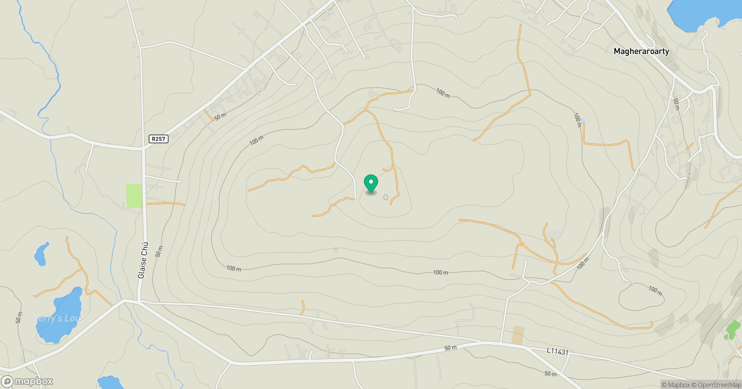
Grid reference: B878320
View on OpenStreetMapOpens a map in a new tab, centred on the hill.
Hills within 30 km
Straight-line distance, not a walking route or confirmation of access.
No comments yet. Be the first.